SUMMER 2025 - THE GRAND TETON LOOP
Photographing and Running Grand Teton National Park
It’s been a few months since my Summer trip to the Tetons, and I’m just now getting around to looking back on the week. Grand Teton National Park was my first national park as a photographer, and has remained a favorite location of mine since. You’ve probably heard of Yellowstone, but I am always surprised by how much lesser known Grand Teton seems to be, just 30 miles to the south. If you asked me to recommend a national park to visit, this would most likely be my first suggestion.
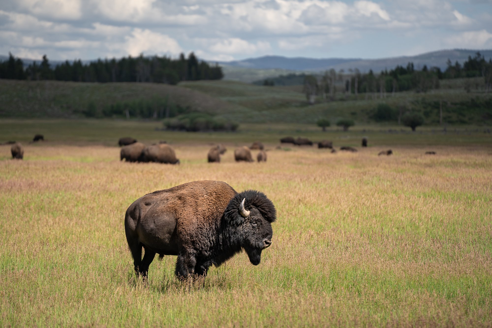
The park offers incredible mountain and lake views with amazing camping and hiking, and wildlife sightings of bison, elk, moose and bear are everywhere. There are many opportunities outside of the park boundaries as well for visitors to go horseback riding or go rafting down Snake River, and you are only a short drive from the town of Jackson and Teton Village/Jackson Hole Mountain Resort. I have visited Jackson Hole multiple times over the years for photography, but this Summer, I returned with the main objective of running the Grand Teton Loop.
In this post, I will recount my time on the trail, discussing some of the preparation and considerations made, and will highlight a few photo locations from throughout the week.
Grand Teton Loop Flyover
The Grand Teton Loop
The Grand Teton Loop is a 35 mile route traversing the Teton backcountry. Starting and ending at Jenny Lake (6,781'), I chose to complete the route clockwise. This let me to view the Eastern side of the Tetons when they looked their best under morning light, while being on the backside of the range later in the afternoon. It also allowed me to get 12 miles of relatively flat trail out of the way first when I was fresh, while giving myself a fully downhill final stretch back to Jenny.
Grand Teton Loop route and elevation
I envisioned my run as three sections (visualized in the “Grand Teton Loop route and elevation” map):
The first 1/3 of the loop follows the wooded Valley Trail to Death Canyon. Starting at the South end of the Jenny lake parking lot, I began by taking the Exum Trail to Moose Pond Trail before crossing a couple of parking lots to reach Valley Trail. Multiple trail crossings within the first mile made it very easy to veer off course. I always import my routes to my watch so l know where l am, and I can be alerted if I make a wrong turn. Turn by turn alerts can also be enabled, but I left them off for this run. These features have been helpful for me many times when trails are not clearly marked or visible, or when route-finding is necessary.
Valley Trail runs in front of the Teton range, and passes by views of Bradley and Taggart Lake. These lakes are also very popular and easy short hikes that can be accessed via the Taggart Lake Loop Trail. The trailhead parking lot, located on Teton Park Road, fills up fast, so prepare to arrive early, and you may get to spot some elk and moose.
From Taggart Lake, the trail continues for another 5 miles before reaching Phelps Lake Overlook. I took a moment here to enjoy the view before heading down into to Death Canyon to begin the big climb.

Bradley Lake
Taggart Lake


Section two covered the next 11 miles, starting with a ~ 6 mile, ~4,100 foot hike up and over the Static Peak Divide (10,790').
My trekking poles broke before l even got started up the canyon. Both poles got stuck in their folded positions, and I spent about 15 minutes trying to pull them open, doing/using anything I could to pry and knock loose whatever was binding them together. I eventually snapped them, and that was that…
The first 2 miles of the climb followed the Death Canyon Trail which ran parallel to Death Canyon Creek, before turning up Alaska Basin. This was my last access to water until my descent from Static, and I was sure to take advantage of the opportunity to filter water before continuing forward. I began to slow as I gained elevation, but once on top, I felt in decent condition.
Large patches of snow remained covering parts of the trail in this area, which felt amazing to take off my pack and lie back on while enjoying a quick break.
I had just entered what turned out to be my favorite section of the entire loop. The 2 mile stretch along the Alaska Basin-Buck Mountain Pass Trail to Sunset Lake offered wildflower-lined trails and stream crossings, with wide open vistas to the West, and the backside of the Teton range to the East. A second ~1,000 foot ascent brought me to the highlight vantage point, Hurricane Pass, as I looked out at the Tetons, and down over the trail leading into Cascade Canyon.
Hurricane Pass is a 23-mile out-and-back through Cascade Canyon, but can also be reached via Paintbrush Canyon, which I am eager to explore on a future trip.This is a location that I'll need to return to with my camera. The views here were mesmerizing, and the warm light casting on the peaks when I arrived couldn't have been more perfect.
I began working my way down the switchbacks to Jenny Lake, with the canyon seemingly growing around me. The loop was taking me longer to complete than I had anticipated, but I was able to get about half way into Cascade Canyon before dark. My breathing felt OK, but the large rocks and roots that I had been running over took a toll on my legs and core, slowing my pace at the end. The final 6 miles were frustrating to complete. When you're so close to the end, but moving much slower than normal, time really drags. In the end, I recorded 37.72 miles in 16h 28m, with ~ 15,100 ft of elevation change.
The run would not have been complete without a cool wildlife sighting. With only a few miles to go, I began noticing fresh droppings on the trail. I wasn’t sure what left them, but I became more vigilant, eventually coming across a moose to my left. Every time I tried to step forward, it seemed to also want to head in that direction, so I stopped to observe for a moment, while waiting for it to move on and cross the trail in front of me, before I continued on to Jenny Lake. It's always exhilarating to happen upon these large animals in the field!
In my pack…

Jenny Lake, July 25, 2025
My run along the Grand Teton Loop was fully self supported. With no services or amenities along the trail, I was prepared to carry all food and supplies needed for the entirety of my run. Cell service was rare once I entered the canyon, and all water had to be filtered from streams and waterfalls, so I was sure to carry along a Garmin InReach mini with SAR100 and Sawyer Squeeze water filter. Bear spray is also a must. Encounters with black and brown bear are always possible, so it is important to be aware and prepared when entering bear country.
I started the day with 2L of water on my back, a 1L water bottle with electrolytes on one shoulder, and a 1L bottle with flattened Baja Blast on the other. As strange as Baja Blast might sound, I’ve found it to be great to sip on for those quick hits of caffeine, sugar, and electrolytes. For snacks, I packed my typical combination of gels, electrolyte tabs, energy chews, pickles and peanut butter M&Ms.
Loss of appetite has been an ongoing issue for me when completing longer distances, and managing this has been a work in progress. I am continually experimenting with different foods and snacks during training to find what is easiest for me to consume when I begin to have difficulty eating.
During my Spring trip to the Adirondacks, I stumbled across a Lemon Orzo pasta salad which really caught my attention. It was light and refreshing, and with this in my pack, I never felt like I was unwilling or unable to eat. I had so much success with it during the week, that I found a recipe, and it has became my go-to meal prep for these long efforts.
The Landscape
I spent the days around “run day” hanging out in Jackson, and around the park. This trip was my first time back since I began shooting square format with the Hasselblad, so I was looking forward to hiking out and exploring some new locations, while also returning to some old locations with a new eye. For the most part, I stayed close to the road. Weather worked out perfectly throughout the week, offering up some great sunrises, sunsets, and even mid-day looked good with clouds rolling over the range.
The following images are a few favorites from the week, two of which are easily accessible from the parking lot, and one challenging hike that is well worth the effort, should you choose. All photos were shot on Kodak Ektar 100.
Sunrise at Oxbow Bend
Oxbow Bend is one of Grand Teton's iconic viewpoints, with Mount Moran reflected in Snake River. This location is easily accessible, with a small parking lot located a short distance after entering the Moran Entrance Station. I've shot this location a few times at sunset, but this was my first time shooting sunrise. Conditions were perfect this morning, calm and quiet as I stood back and watched the mountains change color, and the clouds above glowing reds and oranges. I remember feeling excited about this shot when I took it, and it was one of the images that I was looking forward to seeing the most.
An afternoon at Schwabacher's Landing
Schwabacher's Landing is another popular, and easily accessible location, located off of Hwy 89, about 10 minutes north of the airport. A short dirt road takes you to a parking lot with views of Grand Teton reflected in Snake River. Like many locations around the park, this is a great spot to visit at sunrise, to watch as the morning light illuminates the Tetons. A short, even trail runs along the river to the right for varied compositions. I’ve shot this location numerous times, and It never gets old.
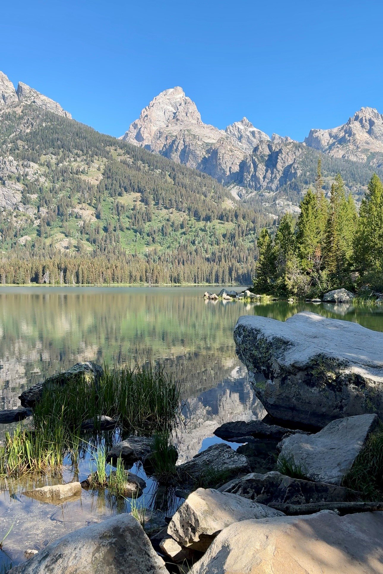
Morning solitude at Delta Lake
I spent my final morning hiking up to Delta Lake.
Delta Lake, via Lupine Meadows Access road, is an 7.5 mile out-and-back that starts off along the Garnet Canyon Trail.
After hitting snooze on a couple of alarms, and then realizing I forgot to refill my water, I finally got started at 4:30am. I worked my way up the ~3 miles of wooded switchbacks before turning off trail toward Delta. The final half mile is a steep, unmarked boulder scramble, and requires some route-finding to climb your way up to this glacial lake. It was very easy to get far off track here, and I was constantly checking my Garmin for direction. As you reach the top of the scramble and step up, the lake sits directly in front of you.
I had the entire place to myself. Clouds had rolled in, blocking the sun when I first arrived, so I found a spot to lie back, while hoping for a moment when the light would shine through just enough to brighten up Grand Teton. That brief opportunity finally came, and I was able to grab this shot before the clouds thickened back up.
This was an amazing view to cap off another memorable trip to Grand Teton National Park. With as many opportunities as I have had to visit, I always leave with a lingering feeling for more, and a strong desire to return.